|
|
|
|||
|
|
|||
|
|
|||
| . . Homepage. . . . What We've Been Up To. . . . About Me & Al. . . . Teddington. . . . Pictures. . . . Puzzles. . . . Puzzles Too. . . . Music. . . . Misc. . . . My Films. . . . Credits etc. . |
|
||||
|
|
||||
|
I attended John Lyon School, Harrow from 1968-1975. In an attempt to contact my classmates from that period I started the Over Surtees Club. Our headmaster Gordon Villiers Surtees started at the school in the same year I did.
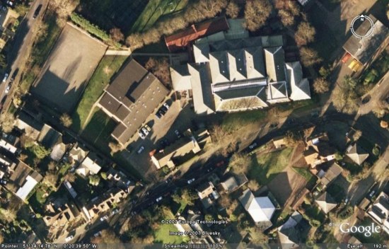
The above Google Earth image, centred on 51°34'14.21"N, 0°20'40.03"W, sadly too enshrouded in shadow, is orientated to the north. The cork pitch is in the NW corner, the Art Room and classrooms 305 and 306 are just south of the car park / playground in the centre, with the former armoury at the north corner, below classroom 3-Alpha. The Red House is just below right centre, with the second form cloakrooms and toilet to its right. The hexagonal building (the six-sided one if you missed maths!) at the other end of the playground is the Music School, with the old storage building along the SE side of the playground. Just NW of the Music School is the woodwork room, with the school caretaker’s cottage to the left, across from the Art Room. Middle Road runs from the SW corner, in front of the main school building, before exiting half way down the east edge. The buildings between the cork pitch (has that been resurfaced?) and the main playground post-date my time there. I remember temporary 4th-form accommodation being erected at the foot of the bank, with a flight of perilously slippery wooden steps leading down. There were some even older ‘temporary’ 5th-form classrooms to the north of the main building, now apparently gone, already looking well-worn during my tenure. To the NE of the main building there was a long brick building, used by the Combined Cadet Force, of which I was the senior rank in my last year. This photograph brings back memories of geography lessons, in which we used to compare and contrast a map and an associated aerial photograph. We used to have to try and decide things like the time of day and the season. I could spend hours doing that now, but I hated it at the time! Geography is wasted on the young. The new John Lyon School website is active here.
|
|
|
 |
|||
|
|
|||
